 University of Wisconsin-Eau Claire students and graduates with knowledge of geospatial technologies are being pursued by businesses and government agencies across Wisconsin and beyond as demand for employees with geospatial skills is soaring.
“Today, if an organization does not employ someone with geospatial skills, it is likely they have a consulting firm that does,” said Martin Goettl, a geospatial technology facilitator in the UW-Eau Claire geography and anthropology department. “These skills are in high demand in the private and public sectors. Our students and graduates who have these skills are being offered internships and jobs in organizations of all kinds and sizes. Demand on our campus for geospatial classes has increased dramatically as our students have recognized how much prospective employers value these technology skills.”
Geospatial technology is a term used by industry and government agencies to refer to the tools (hardware and software) used in global positioning systems, geographic information systems, computer cartography, remote sensing and field sensors that help in acquiring, storing, processing, analyzing and communicating information connected to a specific location.
The U.S. Department of Labor has listed geospatial technology and its use as one of 14 “high growth, high demand and economically vital sectors of the American economy,” and estimates its growth rate to be almost 35 percent annually.
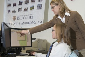
The UW-Eau Claire geography and anthropology department has been educating students in the geospatial realm for many years, and through Blugold Commitment funding, a student-supported differential tuition increase that is invested in academic programs to add value and enhance student learning, the department is prepared to keep up with the increase in demand.
In 2011 Blugold Commitment funds were used to hire one new faculty member and one new academic staff member in the geography and anthropology department. Dr. Cyril Wilson, a human-environmental geographer with expertise in GIS and remote sensing, and Martin Goettl, a geospatial technology facilitator. Blugold Commitment funds were again used in 2012 to create a new 28-seat department lab for use in geospatial teaching to enhance effective learning and use of the technology.
The new lab is being used by students from at least 10 other majors on campus, including biology and geology, as well as others interested in geospatial techniques, and has doubled the number of students able to use geospatial technology. The addition of the staff members and lab gave the department of geography and anthropology the ability to expand course offerings in the area of geospatial technology leading to the design of a certificate program available in fall 2013.
UW-Eau Claire alumnus Rachel Otte, Sheboygan Falls, said she believes her competency using geospatial technology helped her obtain an important internship with the town of Greenville, and ultimately a career with Applied Data Consultants in Eau Claire, one of the largest GIS firms in the Midwest.
Otte graduated in 2011 with a double major in geography and mathematics. During her internship in Greenville, Otte worked on mapping utility structures in the area by collecting GPS points with geospatial software and imported the data into an existing database to update the town’s infrastructure database and create an up-to-date map.
“I was very confident in my internship work because I had experience with the same software Greenville used during a UW-Eau Claire field seminar trip to Honduras in 2010,” Otte said. “We studied boa constrictor habitats by recording their GPS locations and collecting environmental data to see the type of conditions they prefer. That experience gave me familiarity with the technology before even starting my internship.”
When Otte began work at ADC, her first job was to map parcel contracts for government agencies using the same GIS technology she had become familiar with during her undergraduate work.
“I was a step ahead when I started at ADC because I had acquired a lot of technological skills as an undergraduate during different labs in my courses and field seminars,” Otte said. “I had experience using ArcMap developed by ESRI, the leading technology provider within the industry. That was really impressive to my employer. Any employer appreciates when an employee has an existing working knowledge of basic technological tools.
“It’s pretty amazing what we have here at UW-Eau Claire. The professors really prepare you to succeed in the workplace,” Otte said. “Having numerous experiences using geospatial technology and data processing in the field allowed me to develop my skills and gave me the confidence to go out and find my career in the field.”
Geospatial technology is a tool used in a variety of organizations and public services. Private-sector businesses that use geospatial technology include market analysis and site location firms, utility companies, mining industries, insurance agencies, environmental consulting firms and businesses in the medical field. Government agencies, such as the U.S. Census Bureau, U.S. Department of Agriculture, Centers for Disease Control and Prevention, and Department of Natural Resources, all use some type of geospatial technology.
“One of the most powerful aspects of GIS is the ability to overlay multiple layers of information,” said Dr. Christina Hupy, assistant professor of geography. “Anything that has a spatial component can be studied using geospatial technology. It was used during the election to assign voting districts and map and analyze the results. It was also used during Hurricane Sandy through weather satellites, sea-level surge projections, emergency routing, FEMA distribution planning, emergency services and shelter location planning.”
Hupy also said most counties within the state of Wisconsin use GIS in some way to map areas, such as parks and city zoning, assess transportation needs and routes, and monitor animal populations. The Wisconsin Department of Administration recently published a report by the Wisconsin White-Tailed Deer Trustee and Review Committee identifying “a gap in technologies needed to provide critical services and effectively manage natural resources. Our specific observations are: The state’s geospatial database system is woefully inadequate to support, not only for wildlife and deer management, but also for many critical services. This is particularly true for economic development, emergency planning and response, and critical services for citizens.”
Hupy said UW-Eau Claire faculty members are prepared to address the need for adequate geospatial technologists in the state.
“Students are learning very industry specific skills as we have designed our courses after the Department of Labor’s geospatial technology competency model, which is a guideline for educators to keep them up-to-date with skills that are needed in the labor force,” Hupy said. “This model has been an immense resource for us and the students. It has helped us align our curriculum with what the industry is looking for, and we are seeing the results in students’ technological competencies.”
Dr. Doug Faulkner, chair of the geography and anthropology department, said the model fits well with the goals of UW-Eau Claire.
“The base of the model, academic competencies, is what we have as the foundation of our liberal arts education and includes geography as a foundational discipline. Academic competency in geography, including broad geographic knowledge and the ability to think geographically, is essential for achieving a high level of competency in geospatial technology. The second tier, workplace competencies, highlights the broad range of learning experiences in geography; and the third tier, industry-wide technical competencies, stresses the education of core geospatial abilities and knowledge. This model puts an emphasis on a solid foundation of knowledge to use technology effectively and confirms our approach to geography and geospatial technology.”
Senior geography major Meghan Kelly, Mankato, Minn., said her knowledge and skills helped her land a coveted internship with GeoDecisions, an information technology company in Madison specializing in geospatial solutions. Kelly worked on a water utility project, converting paper maps into GIS maps for more accuracy and detail.
“I felt confident in my abilities when I started there,” Kelly said. “Being able to use the technologies efficiently made me more prepared for the work than some graduate students who applied for the internship. My skills were a huge asset to the company and my work there will look really good on my graduate school application.
“The education I have had at UW-Eau Claire has really taught me the basic knowledge of geospatial tools and how to apply them to collect and interpret data,” Kelly said. “The professors keep up with technological advances and are aware of where the field is heading in order to prepare us for the real world. This is the key to developing the next generation of geographers. I don’t doubt that I have acquired the skills to be successful.”
Kelly, along with many other students interested in graduate school, recognizes that learning, understanding and applying geospatial technology skills will increase the chance of being accepted into top graduate programs.
“We feel students coming out of UW-Eau Claire are well prepared to use geospatial technologies in in-depth research when they begin graduate school,” Goettl said. “They will be ready whether they choose to study human, physical or international geography, or any other aspect of geography, as well as other disciplines that can employ geospatial technologies, such as geology, biology and public health.”
UW-Eau Claire’s expansion of GIS course offerings and opening of the new department lab for use of geospatial teaching have sparked interdisciplinary interest in learning geospatial technology. Rebecca Moore, a senior geology major from Champlin,Minn., has used GIS software extensively during her past two research projects. In summer 2011 she worked in Polk County, where she used GIS software to create a hiking guide of Straight Lake State Park that was published by the Wisconsin DNR and was presented at the Geological Society of America national conference in 2011. The following summer, Moore worked for an environmental consulting firm in Idaho where she performed geologic mapping in the mountains.
“I worked with a team to gather structural measurements and data, but I was the person on the team who knew how to use GIS in order to input and analyze the data to create a detailed map for the company,” Moore said. “I know having this working knowledge of technology is going to be huge in getting a career in the field.”
Moore is currently working on creating two GIS maps for the state of Montana and hopes to work for an environmental consulting firm doing site remediation and planning after she graduates in spring 2013.
“My experiences working closely with professors in the lab and in the field have given me the confidence to go out into the workforce and know that I can do this as a career,” Moore said. “I have confidence in my abilities to learn and use technology.”