With the mapping business booming thanks to GPS and other technological advances, Continental Mapping Consultants – a long-established Sun Prairie-based company — expects its workforce to top 100 employees by the end of summer.
As it grows its team, the company’s president and co-founder Dave Hart says they are looking more and more to the University of Wisconsin-Eau Claire to provide them with graduates who have the skills and mindset Continental needs from its newest hires.
“There is a certain set of skills that anyone in our business needs and graduates from lots of places may have those skills,” says Hart, who graduated from UW-Eau Claire with a geography degree in 1988. “But we’re looking for people who have learned how to learn, and that’s something that UW-Eau Claire does very well. Their students have very strong skills but they also are open to working hard and learning new things. Eau Claire does a great job with the liberal arts and instilling in students a passion for learning, and it makes a huge difference.”
Even more impressive is the determination of UW-Eau Claire’s geography faculty to understand current industry needs so they can shape curriculum and create experiences that will better prepare their students to succeed in today’s workplace, Hart says.
“They’re willingness to talk to us really sets them apart,” Hart says. “We have way more contact with UW-Eau Claire than any other school. They really are exceptional in that regard. The communication is critical because we can help them understand our current needs, and they can help meet those needs and also talk realistically with their students about what to expect working in our profession today.”

While building relationships with businesses like Continental Mapping has always been important to faculty, a three-year $418,869 grant to support geospatial education has made it possible to invest even more time and resources into reaching out to industry leaders, says Dr. Christina Hupy, a geography professor who is overseeing UW-Eau Claire’s Geospatial Education Initiative (GEI).
UW-Eau Claire received the grant from the Growth Agenda for Wisconsin Grants Program in June 2014 to support its GEI, which was developed by a team of faculty members from the areas of geography and anthropology, physics and astronomy, computer science, and information systems.
Geospatial refers to the technology used in global positioning systems, geographic information systems, computer cartography, remote sensing and field sensors that help in acquiring, storing, processing, analyzing and communicating information connected to a specific location.
The U.S. Department of Labor has listed geospatial technology and its use as one of 14 “high-growth, high-demand and economically vital sectors of the American economy” and estimates its growth rate to be almost 35 percent annually.
A year into the three-year GEI grant, Hupy says already the initiative is helping Blugolds land jobs and internships, and its helping faculty develop new or enhance existing academic programs and classes to better prepare students for success in the growing geospatial field.
Companies like Continental Mapping have hired an impressive number of UW-Eau Claire graduates in recent months, and there is a growing number of Midwest businesses offering Blugolds internships, Hupy says. The GEI-supported outreach efforts, she says, clearly are paying off.
“Our internship development has been a big success,” Hupy says of the GEI team’s efforts. “This year we had one company support six students through internships, while others supported one or two interns. Already some interns are being offered full-time jobs by the companies when they graduate.”
The internships help students enhance their skills, get to know a business, and solve problems on the ground with real data, Hupy says.
“Those are things that we can’t give them in the classroom,” Hupy says. “Students also gain a lot of confidence by putting knowledge into practice during internships, which makes them even more competitive in the job market when they graduate.”
The GEI team invested some of its grant dollars in video conferencing technology, which has created new kinds of internship opportunities, Hupy says. Using the new technology, students completed internships with companies in Kansas City and Minneapolis while staying in Eau Claire to continue their on-campus coursework.
The remote arrangement gave students internship experiences without incurring the financial and other costs associated with relocating, Hupy says, noting it also kept students on track to graduate because they took classes while also working as interns.
In addition to the typical skills gained from internships, the remote arrangement also gave the students professional experience using conference calling, email and other communication tools, Hupy says.
With geospatial skills in increasingly high demand in a variety of businesses and industries, internships are even more important because they expose students to the range of opportunities available to them when they graduate, Hupy says.
While many graduates still find jobs in mapping and other businesses that traditionally have hired geography majors, many other industries also now are hiring employees with geospatial skills, Hupy says. Insurance companies, utility companies, software companies and environmental consulting firms are just a few examples, she says.
“One of the exciting things about this field is that you can work in a core industry or any of these places that increasingly are using geospatial technology,” Hupy says. “Polaris in the Twin Cities is a good example. They build off-road vehicles for military and recreational users, but they need maps for those vehicles. They’ve already hired one of our recent grads, who now is supervising one of our interns.”
The growing demand for employees with geospatial skills means students have more opportunities to combine their other interests with geospatial technology to build niche careers, says Brandon Schleicher, a 2013 graduate who works for Continental Mapping.
“The geospatial field is a large territory so I’d encourage future grads to find a specific niche to fit into whether it be in local government, oil and gas, geo-intelligence, or one of the many others,” Schleicher says. “They should use their interests to tailor their education in the direction they want to pursue.”
Blugolds with geospatial skills are finding jobs and quick success in the workforce, particularly those who took advantage of the many high-impact experiences UW-Eau Claire offers, says Hupy.
“We’re seeing our grads move up quickly in the ranks especially if they’ve taken advantage of the internship, research and networking opportunities they have on campus,” Hupy says. “Some of them are jumping a whole rank. The kind of jobs they’re getting are jobs you typically don’t get right out of school. But they leverage their experiences here when they get in the job market and it’s really paying off.”
The stronger relationships with business and industry leaders is helping faculty better identify program strengths and weaknesses so they can revamp curriculum in ways that better meet current and future workforce needs, Hupy says.
UW-Eau Claire’s GEI team is especially excited about a proposed new geospatial major, which is making its way through the review process. If all goes as planned, the new major will be available by fall 2016.
“We’re offering innovative, relevant curriculum,” Hupy says of the proposed geospatial major. “We’re taking an interdisciplinary approach. For example, we’re integrating computer programming into our core curriculum, and we’re working together to bring geographic data into their curriculum. We’re working closely with STEM faculty. We’re excited about all these partnerships and what they will mean for our students.”
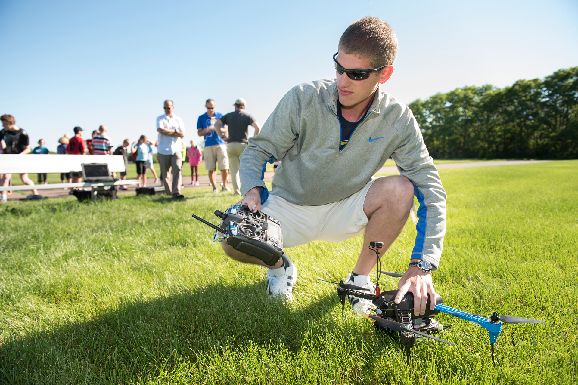
While the proposed major is still a year away, already this fall students can enroll in new and revamped geospatial classes, including UW-Eau Claire’s first class in Unmanned Aerial Systems, which will be taught by Dr. Joseph Hupy, associate professor of geography.
The department also plans to add specialty options to its existing geospatial certificate program, which also includes an area of specialization in UASs.
Unmanned Aerial Systems, commonly referred to as drones, have the potential to solve geospatial problems in ways never before imagined, experts say. The rapid development of UASs is possible as technology mounted to the devices has become lighter, smaller and less expensive.
Interest in UASs has soared as their uses have been considered for everything from agriculture and forestry management, to insurance assessments, and search and rescue missions, Hupy says.
“Students will learn about cutting-edge software and the many potential uses for it,” Hupy says of the UASs class. “The focus is from the geospatial perspective. It’s about properly planning to gather needed data and processing the data. Most programs focus on the mechanics of how the system works, but this is different because it gets at how to plan, analyze and process the data to get the information a business needs to make important kinds of decisions.
“This is technology being used by a lot of different kinds of businesses and industries from utilities to agriculture to insurance companies. A retail business might use it to decide where to build their next store, while an insurance company might use it to access damage from a natural disaster.”
UW-Eau Claire is building a geospatial technology program that is more comprehensive than anything that exists in the Midwest, Hupy says.
“Many places have pieces of this but we’re building something that brings it all together,” Hupy says. “We offer global positioning, geospatial field methods, data management pieces, as well as the UASs, business graphics and LiDAR. We’re offering students a whole package of classes so they can take away a more highly specialized set of skills. That’s unique to this campus.
“And if you add in all the experiential learning that UW-Eau Claire excels in then it’s even more impressive. You bundle our GEI courses and programs with the internships, independent study, field work, networking and research that we do so well here and it makes an attractive program that you won’t find anyplace else.”
Current and future students are paying attention to the new opportunities available in this high-growth field. The number of geography majors — 120 — is at an all-time high at UW-Eau Claire, and the number of students taking one of the geospatial capstone course doubled in the spring semester.
Drew Briski, a 2014 geography graduate, was among those whose career path changed after he became intrigued by the opportunities in the geospatial technology field.
“I never knew the geospatial industry existed until I got to UWEC and took some intro geospatial courses,” says Briski, who works for Continental Mapping. “I’ve always been interested in maps, but when I started to actually make them is when I became interested in going into the geospatial industry.”
A growing number of non-geography majors also are taking geospatial courses, including students from the College of Business, Hupy says.
“Students see this skill set as something that’s desired by employers,” Hupy says. “If they have it, they’re more competitive in their job search. The increased use of geospatial through the rise of google maps and other very accessible technology has students thinking about these skills in different ways. Many students are naturally spatial thinkers so when they also see how analytical geospatial is and they like technology, it’s a perfect storm. They like it and think it’s cool so they are drawn to it.”
As technologies continue to advance, even businesses that have had long depended on geospatial talent are re-thinking the levels of education their employees need to be successful, says Hart.
For example, the surveyors Hart’s company hires typically have core skills first learned at technical colleges, but often many of them supplement those skills with geospatial or engineering courses or additional degrees.
“Eau Claire is ahead of other similar schools in recognizing that technology has advanced so much that there are new skills that now need to be taught at the university level,” Hart says. “Many higher education institutions have been slow to accept that some jobs that used to be considered more blue collar — like surveyors — now require that additional skills be developed through a four-year degree. We need employees with strong technical skills but also with the liberal arts skills because they have to know how to learn, how to communicate, how to think critically and how to solve problems. UW-Eau Claire does a good job of balancing the liberal arts with the more technical skills. They’re recognizing those needs and working hard at it.”
Joel Albrecht, a 2013 UW-Eau Claire graduate, is a geospatial analyst at Continental Mapping. Now that he’s in the workforce, he clearly sees the value of having both the geospatial and liberal arts skill sets.
“Anyone can press buttons on a keyboard and learn the technology, but it’s knowing what to do with the data and thinking creatively that will really make the difference in job success,” Albrecht says. “My professors were passionate about encouraging critical thinking and that helped foster my education. I enjoyed the hands-on learning activities because they allowed us to apply theories instead of just passively learning. They did an excellent job of using real world scenarios in projects they assigned to us, and that helped me see how powerful the pairing of classroom knowledge and technology can be.”
Given how quickly the geospatial field is changing, ongoing communication between university faculty and business leaders is critical to preparing students for future success, Hart and Hupy say.
“We like to know what students are they learning, and what are they’re looking for in their careers,” Hart says. “Young people are idea factories and we love that about them. We also want faculty to know the skills we value most so they can build coursework around those things. When we’re having those kinds of conversations with a university, we’re going to hire their graduates because we know they’re going to do well here.”
The positive response from business and industry leaders like Hart is encouraging, Hupy says, noting that nurturing and enhancing those kinds of relationships will continue to be a priority.
As part of its ongoing efforts to strengthen partnerships with business and industry leaders, UW-Eau Claire’s GEI team will host its second GEI Business Summit on campus in August.
For details about UW-Eau Claire’s Geospatial Education Initiative, contact Dr. Christina Hupy at 715-836-3313 or hupycm@uwec.edu.