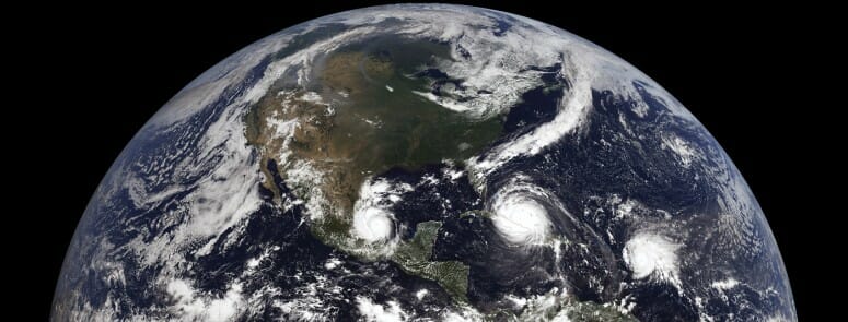
With the 2022 Atlantic hurricane approaching in June, forecasters at the National Oceanic and Atmospheric Administration’s National Hurricane Center will have access to the most advanced storm measurement software yet to help them save lives and property with timely warnings.
The well-established, satellite-based method for determining tropical cyclone intensity known as the Advanced Dvorak Technique is receiving a significant upgrade within NOAA operations in time for the 2022 Atlantic hurricane season. Upgrades to the ADT include the use of full-resolution images from weather satellites, better identification of the storm eye location and the ability to analyze hurricanes occurring outside of tropical regions.
Developed by researchers at the University of Wisconsin–Madison Cooperative Institute for Meteorological Satellite Studies, the ADT has benefitted over the decades from user feedback, especially from forecasters who rely on it to deliver more rapid and accurate analysis of storm development.
“For us the goal is to provide a tool so forecasters can do their jobs better,” says CIMSS researcher Tim Olander. “We have always tried to support them by incorporating their recommendations and ideas for improving our algorithms.”
The ADT provides an indication of how a storm might strengthen — especially one approaching populated coastal areas. In addition to Atlantic hurricanes, the system works well for storms outside the Atlantic Ocean, where direct measurements can be more difficult to come by.
Because landfall preparations and evacuations are costly and disruptive, accurate forecasts aided by the ADT can have huge implications for emergency planners who must decide whether to issue an order and for residents who must follow it. These forecasts are made even more accurate by combining the ADT with direct measurements of storms and satellite imagery.
“The ADT itself is not a prediction tool, but it does help describe the current state of tropical cyclone intensity, which provides the critical starting point for both forecaster and model-based predictions of future track and intensity,” says senior scientist Christopher Velden, who leads the CIMSS Tropical Cyclone Group.
The original Dvorak Technique was first introduced in the early 1970s by NOAA researcher Vernon Dvorak as a method to estimate hurricane intensity by analyzing visible and infrared satellite images of a storm. It was a labor-intensive process requiring manual interpretation and comparisons of images over time to detect common patterns, such as the intensity of the convection, cohesiveness of cloud bands and the development of the hurricane’s eye. These estimates could take up to 20 minutes to construct by hand and were less accurate when the hurricane lacked a well-defined eye.
Since then, advances in satellite meteorology have revolutionized the field, enabling forecasters to see hurricanes as they travel across the Atlantic Ocean or other bodies of water. Weather satellites like NOAA’s GOES-16 capture visible and infrared imagery of a storm every 30 seconds. The increased frequency of the images, combined with modern computing and analysis techniques, has enhanced the accuracy of the Dvorak Technique.
CIMSS researchers took advantage of emerging satellite capabilities and developed the ADT in the late 1990s, building on Dvorak’s earlier methods. Use of the ADT has expanded beyond the National Hurricane Center, and it is now used to analyze tropical cyclones around the world, including those form in waters around Australia, Japan, India and Hawaii.
Looking ahead, the CIMSS Tropical Cyclone Group will continue to improve satellite-based applications like the ADT to increase accuracy and reliability.
“The use of artificial intelligence methods to analyze large datasets is exploding in the research world, and our group is no exception,” says Velden. “We are already testing a new version of an AI-enhanced ADT that may someday replace the current version in operation. More accurate hurricane analyses contribute to improved warnings that lead to better public preparations for an approaching storm, ultimately reducing the negative impacts on coastal populations.”
This work is supported by NOAA.
Written by Eric Verbeten
Link to original story: https://news.wisc.edu/uw-hurricane-application-gets-upgrade-in-time-for-2022-hurricane-season/